A popular area for generations young and old, the neighbourhoods of Cherryhill, Oxford Park, and University Heights have long maintained a welcoming atmosphere.
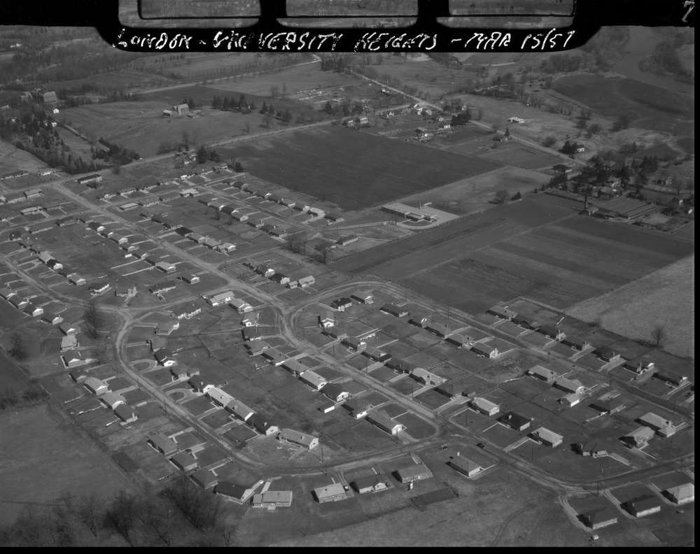
Indeed, one reason the area has managed to cultivate such a reputation for community is its heavily residential landscape. In University Heights, there are a plethora of single-detached houses west of Western Road, dating back to the 1970s and 80s, as well as some high-rise apartment buildings. It’ll come as no surprise that there are also many Western University residences and housing geared towards students in the aptly named neighbourhood. In addition, residents can enjoy the many trails and forested areas found close to the Deshkan Ziibi / Antler River / Thames River.
Where the Cherries Grow
In the 1860s, the area in and around Cherryhill was known, fittingly enough, for growing cherries. Throughout the late nineteenth century and well into the twentieth century, the area largely remained as farmland, with residences only sparsely dotting the landscape.
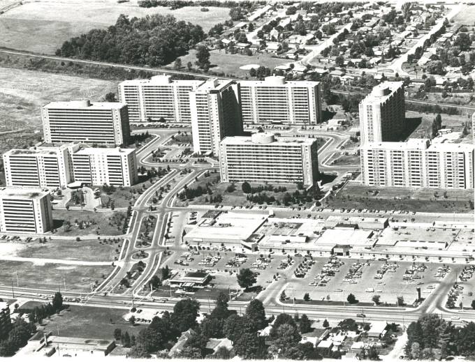
However, Cherryhill has now become known for its high density of apartment buildings; in fact, the Cherryhill Apartment Community in London, Ontario was one of the largest apartment complex sales in Canadian history. Designed as “a city within a city,” the neighbourhood boomed beginning in the 1950s, quickly moving from rural to urban. The area now has a high proportion of both older adults and students, thanks in part to its proximity to Western University and its accessible housing style.
A Strong Community
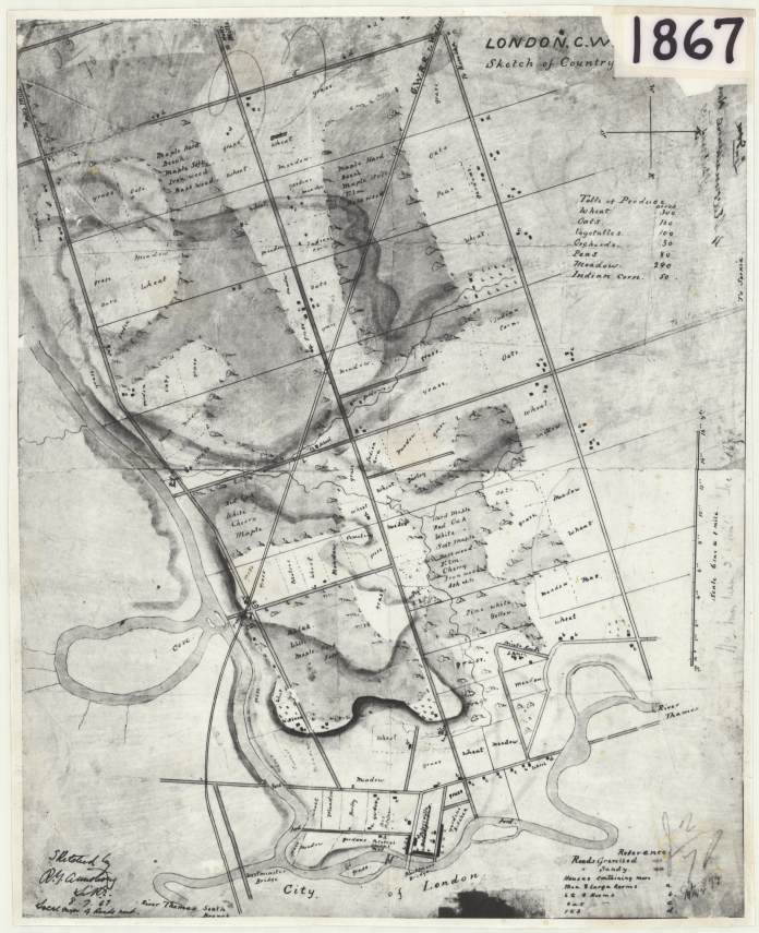
Cherryhill’s neighbour to the south is Oxford Park, a small cottage-like neighbourhood north of the river. As detailed on the above map from 1867, aside from the cemetery, the area that is now Oxford Park was largely grassy fields and meadows prior to the 20th-century.
Now bordered by Oxford Street West, Mount Pleasant Cemetery, the Petersville ravine, and Riverside Drive, it is highly residential and filled with large mature trees. Their fierce sense of community has existed for decades and was tested on a fateful day in August 1973.
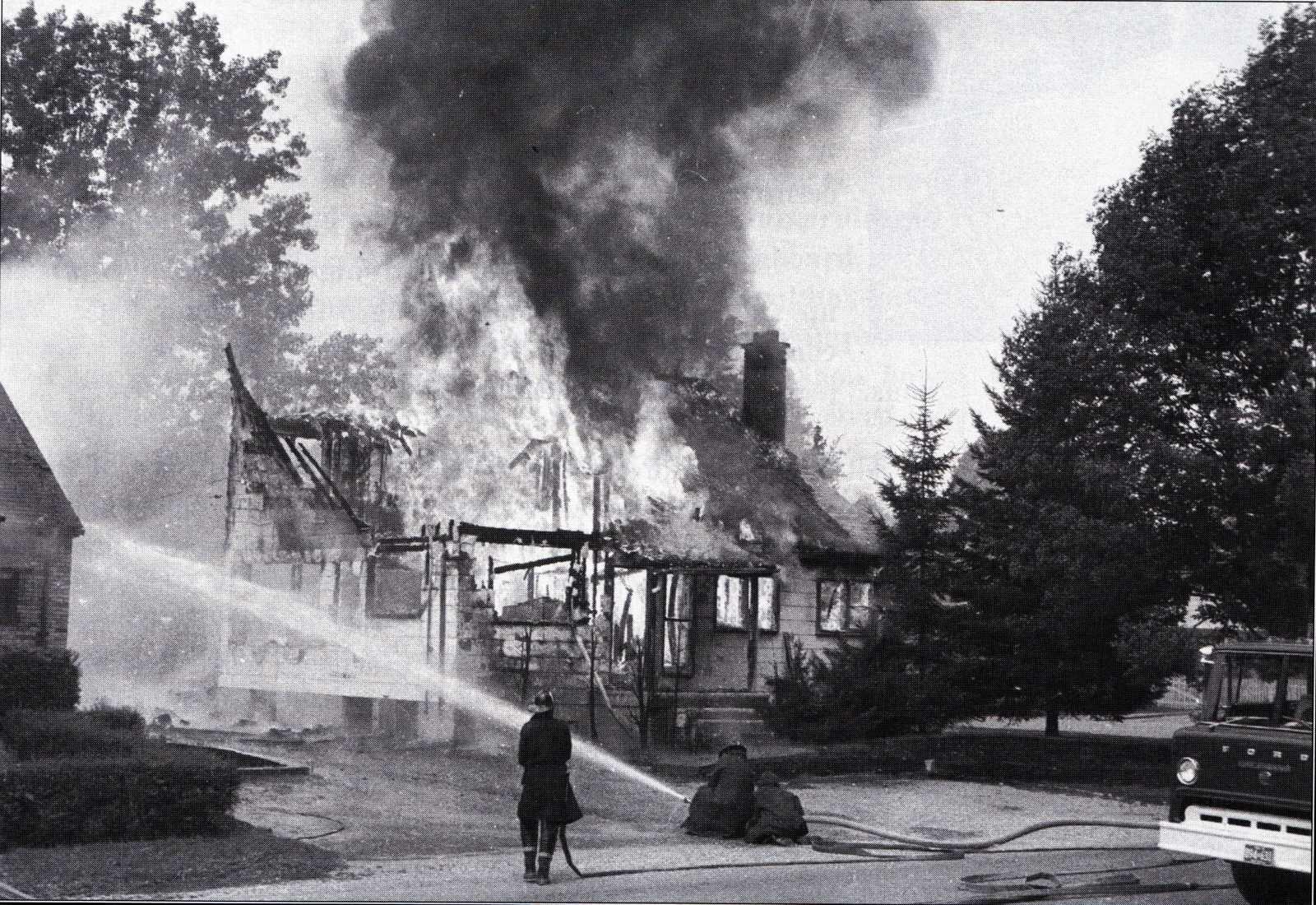
A natural gas valve was damaged during construction on Paul Street, causing a massive leak that led to a series of violent explosions and fires on August 7, 1973. Approximately 38 houses caught fire, explosions destroyed ten homes across several streets, and over three thousand homes were evacuated. Thankfully, largely due to the mid-day timing of the explosion, no one died, though 28 people had minor injuries.
A Final Resting Place
Located next to Oxford Park lies a non-denominational cemetery — Mount Pleasant Cemetery and Oakland Cemetery. Oakland Cemetery was opened in 1855 by the United Presbyterian Church Congregation on the site’s west side. In 1864 the Wesleyan Methodist New Connections Church also instituted its own cemetery on the east side, and in 1882 the two groups decided to amalgamate their holdings into Oakland Cemetery. The cemetery was left unattended and largely neglected for many years, save for the efforts of a Reverend Elson in the early 1950s and Oakridge Secondary School students who undertook Project ‘75 with another cleanup.
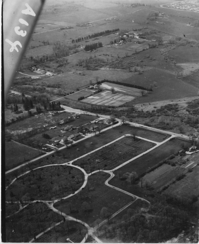
Unfortunately, their efforts were never continued. Oakland was transferred by deed to Mount Pleasant Cemetery in 1982 on the basis that Mount Pleasant would “rebuild and redesign” the property. In a tragic twist of fate, all of the historical burial and lot records were destroyed in a house fire many years ago. While the exact number of interments remains unknown due to the practice of unmarked graves, the estimates range from 350-574 burials.
This area is also home to the Or Shalom Cemetery. Established in 1888, the institution’s history can likewise be linked back to 1940 with the incorporation of the first Conservative synagogue in London, the United Jewish League. In 1944, the United Jewish League joined with B’nai Israel, an Orthodox congregation in south London, and assumed this name. In 1960, B’nai Israel moved to a new building at Huron and Adelaide streets and, with its amalgamation with B’nai Moses ben Judah in 1966, Congregation Or Shalom was born. Today, London’s Jewish cemetery is located on Oxford Street West at Proudfoot Lane.
A Lodge’s Legacy
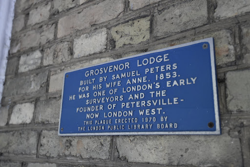
A historical fixture in University Heights is Grosvenor Lodge, a beautiful heritage property located at 1017 Western Road. Grosvenor Lodge was originally built by Samuel Peters and his wife, Ann Philips, immigrants from Devon, England. Leaving in 1835, it took the couple six weeks to cross the Atlantic. After landing in Quebec City, the pair travelled to London by riverboat, barge, and wagon.
Initially, the family resided on Ridout Street, where Peters built a house and a butchery. He worked as a surveyor in London and elsewhere for the Canada Company. Then, in 1850, Peters purchased a brewery west of Blackfriars Bridge, in an area he had surveyed and subdivided. It came to be known as Petersville. Peters was civically engaged, and an overall respected citizen. He was not only a founding member of London’s first Masonic lodge, but he also helped lay the cornerstone of St. Paul’s Cathedral in 1844.
Made of Brick
In 1853, Peters enlisted the help of his architect-surveyor nephew, Samuel Peters, Jr., to prepare designs for his Victorian-style residence. The Peters’ bought 500 acres of land; work on the home began in 1853, and the family moved in a year later. Its Tudor Gothic style was inspired by a manor house in Merton, Devonshire, England, that Mrs. Peters was familiar with and was one of the first brick residences erected in the city. The lodge remained within the family for three generations over 120 years.
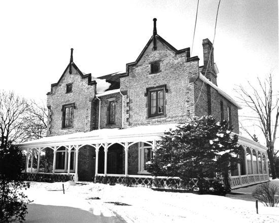
Some of the lodge’s more remarkable features include its locally crafted stained-glass windows, encasing “S.P.” for Samuel Peters, and “A.P.” for his wife Ann Philips, in the design of the sidelights as well as an entwined “S” (Samuel) and “A” (Ann) in the fanlight. Another noteworthy element of the property is the stonework of the gables and windows. Similarly, the plaques in the matching front elevation gables encase “S.P.” on one side and the construction date “1853” on the other. The interior of the home features wide-planked pine floors and individually carved marble fireplaces. As well, the Gothic Revival fireplace in the dining room is particularly unique.
A Reputation for Education
The northeast corner of University Heights is, unsurprisingly, home to a section of Western University, including several student residences and the Faculty of Education.
Founded on March 7, 1878, the then-named “Western University of London Ontario” welcomed students to its campus for the first time in 1881. The first campus was located in Old North’s Bishop Hellmuth neighbourhood. In 1916, the university purchased the land for the current campus from the Kingsmill family.
Western University’s Faculty of Education, originally called the Ontario College of Education, opened in 1962 as the second secondary teacher training institution established in the province. In fact, the south-half of the building served as the Department of Education for Ontario. Over time, the Department of Education expanded and eventually moved out. On April 16, 1963, the building was renamed the Althouse College of Education. At this point, the College remained only affiliated with the nearby University of Western Ontario. In 1973, London Teacher’s College (Elborn) merged with Althouse College to form the Faculty of Education at Western.
A Place for Worship
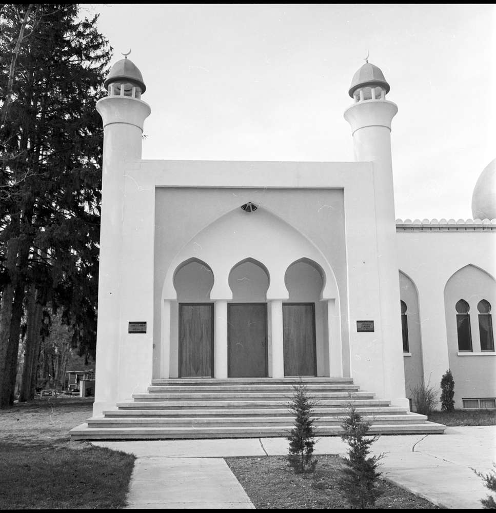
The heart of the local Muslim community, the London Muslim Mosque is Ontario’s oldest mosque and Canada’s oldest operational mosque. Located prominently on Oxford St. West, the London Muslim Mosque was the first purpose-built mosque in Ontario, the second in Canada, and the third in North America. The Muslim community first took root in the city in 1901, when a small group of Lebanese immigrants came to London. To help each other adjust to their new home, the group started the Syrian-Lebanese Club. This club was neither political nor religious in nature; its aim was simply to foster a sense of community and belonging.
Throughout the 1940s and ‘50s, families would meet in each other’s homes every weekend to socialize and teach religion and culture to their children – who were the first generation of Muslims born in London. The community was small but vibrant. In 1955, London’s Muslim community consisted of only twelve families. In the 1950s, the Canadian Moslem Benevolent Society (CMBS) was created with a goal in mind: to locate and establish a commonplace of worship for London’s growing Muslim population to build a strong foundation for the Muslim community. The society was successful in this aim, for their work led to the creation of one of the most unified and active Muslim communities in the country.
A Community Milestone
In 1955, London hosted the fourth annual Muslim convention in North America. During the convention, CMBS shared that it was going to purchase property for a mosque. After much fundraising, the Society bought a house at 151 Oxford St. W — a huge milestone for the London Muslim Mosque. Tragedy struck a few years later, however, when a fire destroyed the building.

A new mosque was erected in 1964 on the same site thanks to generous donations from Muslims all over the continent; it is the one that still stands today. The London Muslim Mosque is a community hub that provides cultural, social, and charitable service to the community. Today, the city’s Muslim population consists of families who have lived here for generations as well as immigrants from many countries, and London is now home to more than five mosques.
A City Within A City
The Westown Plaza, now known as Cherryhill Village Mall, opened in 1960. It was designed as a one-stop shopping destination to serve the growing neighbourhoods.
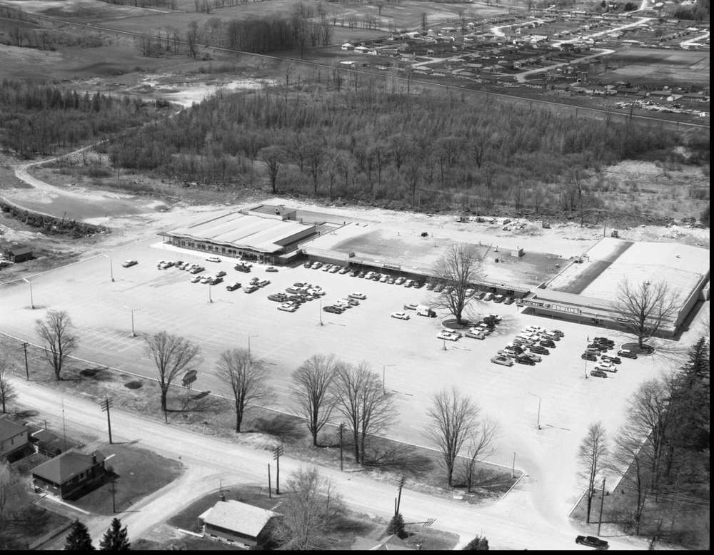
When it first opened, it featured twenty-two retail outlets, including a Steinberg supermarket, Young Canada, The Bank of Nova Scotia, Holt Powell Men’s Wear, Dewars Jewellery, Westown Pro Hardware, Wickhams, and Fleetway 40 bowling. Many West Londoners will remember frequenting The Bavarian Tavern and Restaurant. The Westown branch of the London Library, now known as the Cherryhill Branch, opened in 1963 and, in 1990, became the first full-service branch with six full-time staff.
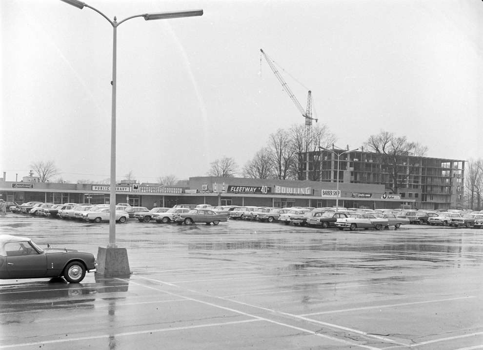
The plaza was — and remains — the beating heart of “Cherryhill Village,” where bowling alleys, a health spa, library, medical centre, two pools, shopping facilities, and tennis courts are just a short walk from a dozen high-rise apartment buildings. One of the men responsible for this development was Sam Katz. Affectionately known as the “Mayor of Cherryhill,” Katz built on the idea of “a city within a city” by creating a well-planned apartment and shopping centre complex on Oxford Street West.
The Mayor of Cherryhill
Katz was an influential entrepreneur and formidable figure in the London community with a heartbreaking past. Katz was born in 1917 in a small village in Austria-Hungary, now Slovakia. During the Second World War, he was held captive in Nazi concentration camps for five years. Witnessing and experiencing atrocities, Katz and one of his sisters were their family’s only survivors. His two brothers, his father, and one sister and her children were killed in Auschwitz.
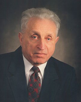
In 1949, he came to Canada and met his future business partner Ewald Bierbaum a few years later in the unemployment line. Shortly after, they began building houses and duplexes as Katz & Bierbaum Construction. From 1957 to 1989, the pair built over four thousand apartment units, a commercial mall, a bowling centre, office buildings and acquired some undeveloped land. The apartment complex behind Westown Plaza was first known as Green Acres, later changing to Cherryhill.
Bierbaum chose to pursue his own interests in 1989, and so the Katz family and partnership group retained the branding and identity of ESAM (a merger of Ewald and Sam’s first names). In 1999, the father of high-rise living in London was named to the mayor’s first seniors’ honour list. The Cherryhill apartment community remained in the Katz family until 2011.
Whether through its communities today or its feats of the past, Cherryhill, Oxford Park, and University Heights continue to prove that above all else, they are neighbourhoods that foster learning and growth for all who reside there.
Feature Photo of Westown Plaza in 1967, courtesy of Western University Archives via historypin.org.
Source: https://londonfuse.ca/london-neighbourhood-histories-cherryhill-oxford-park-university-heights/